


30 and 90 Day Forecast
30
Day
Ensemble Maps
May 6 - Long Range Summary
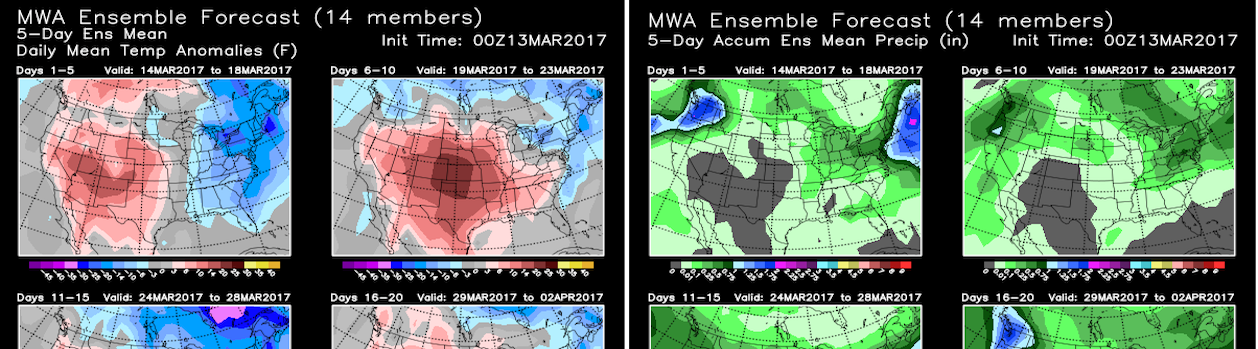
A cold and wet end to this past weekend across the Northeast featuring near 15° below average daytime high temperatures (mainly 50s) did not last more than one day. Starting today all models agree large scale atmospheric pattern repetition will generate another several consecutive day period of sharp temperature contrast across the U.S. between unseasonably cold air draining into the West (with late season mountain snow), and well above average warmth across the Midwest, South, and East likely to again approach or exceed longstanding heat records in the mid Atlantic region (90s) and South Texas (100s). In between another multiday period of severe thunderstorms capable of producing hail and tornados are certain across the central U.S. this workweek along the boundary between unseasonably warm and cold air. However, all extended range models initiate large scale pattern reversal by next weekend (May 11-12) directing cooler and drier Canadian air east of the Rockies for a an approximate 10-day period, while the West begins prolonged warming. The Canadian airmass settling into the U.S. east of the Rockies in mid May is far from cold generating only seasonal level cooling across northern states, but when displaced farther south will produce greatest cooling across the Southeast (7°-10° below average). This is not significant cold as climatological high temperatures across the South in mid May are solidly in the mid-upper 80s. Longer range guidance agrees above average warmth will spread back east of the Rockies after May 20 in a stable summerlike (low amplitude) pattern likely to persist into early summer. Near term heat near 10° above average forecast early this week even in saturated areas of eastern Texas and the lower Mississippi Valley by high resolution short range models is educational guidance supporting return of similar significant heat across far more widespread areas east of the Rockies adding confidence to a relatively hot start to summer.
If your business or career depends on correctly predicting the weather, you can follow the pack or you can get ahead with MWA’s proprietary models and expert forecasts.
Model Data
Custom Tools
Consulting
Our Proprietary Forecast
For more than a decade, the most accurate weather forecasts over any time scale have come from only one source Melita Weather Associates
We owe our success to three factors:
- Our World Class Meteorologists and Climate Scientists
- The Industry’s Only Operational Climate Based Weather Model
- Specialization in Weather Products for Markets and Traders
Our Customers
Melita’s forecasts are written for professional traders and business people in Weather Impacted Business.
- Energy Traders
- Commodities Markets
- Large Scale Producers
- Governments
- Electric Utilities
- Hospitality & Recreation
Melita’s information packed forecasts assume a knowledge of weather patterns and their implications.30 and 90 day forecasts are written to deliver vital information while saving time for busy professionals.At the same time MWA forecasts have considerable detail and are backed up by our personal consultation services.