2008 Forecast Verification Summary
Weather during Winter 2007 / 2008 and Summer 2008 have had largely unexpected Energy Sector implications to those not advised of Dave Melita’s accurate long range forecasts.
Winter 2007/08 Temperature and Precipitation Forecasts Issued October 2007
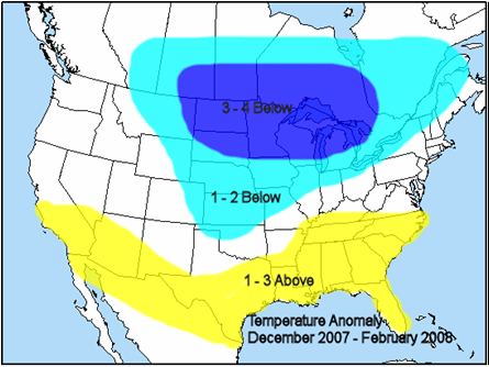
2008 Temperature Anomaly Dec 2007 to Feb 2008
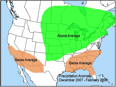
Precipitation Anomaly Dec 2007 to Feb 2008
Winter 2007 / 08 Mean Temperature and Precipitation Verification
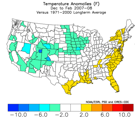

At the end of winter of 2007/08 the largely unexpected low natural gas storage condition made the upcoming summer forecast all the more critical. The fundamental basis of Dave’s forecast issued May 2008 was that summer 2008 would average much more moderate than the excessive heat of the preceding summer 2007 in the major energy consuming areas of the Midwest and East.
Summer 2008 Temperature and Precipitation Forecasts Issued May 2008
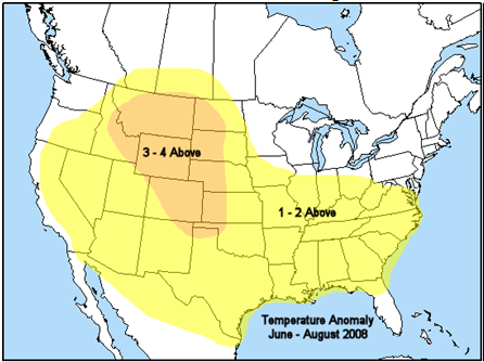
Temperature Anomaly June to August 2008
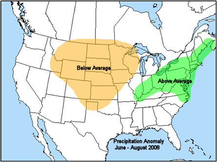
Precipitation Anomaly June to August 2008
Summer 2008 Mean Temperature and Precipitation Verification

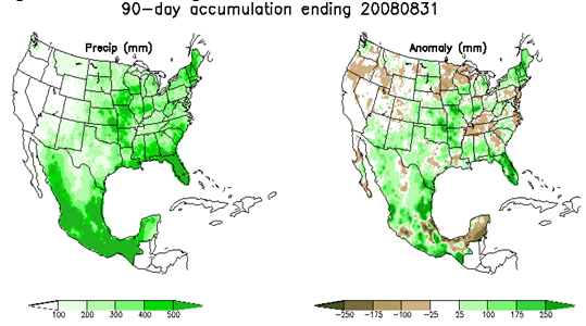
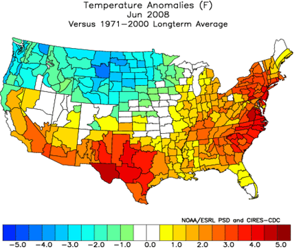
Among the listed primary forecast components issued in May was the following: “June is forecast to represent the greatest positive departures from average temperatures in the northern mid Atlantic and Northeast of the upcoming summer.”
Dave’s June Forecast

Observed June 2008
October 21 - Long Range Summary
Warming underway across the Eastern half of the U.S. is occurring faster than any model previously forecast. Temperatures are still rising and near certain to peak 20° above average or more across the Great Lakes (80s) and Northeast (upper 70s) during the 1st half of this week before a brief shot of cooler air arrives Oct 23-24. However models continue to back-off intensity and duration of late week cooling across the northeast quadrant of the U.S. (seasonal temperatures at best) with little to no penetration of cooler air farther south into the core of near record heat entrenched across Texas and the lower Mississippi Valley (upper 80s-90s). This persistently hot Southern airmass will spread back northward into the Great Lakes and Northeast at the end of this week (Oct 25-26), to likely again peak warmer than models forecast through the end of October (15°-20° above average or more). In the West colder air spreading into interior areas produced high elevation snow in the Rockies and interrupted prolonged record heat which persisted several weeks into mid October. However, Western cooling arrived weaker than models forecast (slightly-moderately below average), and fast warming already underway has latest forecasts shifting hotter back near record levels across the Southwest (mid-upper 90s) for several consecutive days this week. Modestly cool (and wet conditions) lingering in the Pacific Northwest are now forecast to expand across more of the West during the 11-15 day period, but extended range models have been performing poorly and appear to be overestimating magnitude and duration of Western cooling. Regardless of intensity details periodic Western cooling is a warm signal across the Eastern U.S. adding confidence to greater resilience to unseasonably mild temperatures east of the Rockies through November totally devoid of significant below average temperatures.
If your business or career depends on correctly predicting the weather, you can follow the pack or you can get ahead with MWA’s proprietary models and expert forecasts.
