2008 Forecast Verification Summary
Weather during Winter 2007 / 2008 and Summer 2008 have had largely unexpected Energy Sector implications to those not advised of Dave Melita’s accurate long range forecasts.
Winter 2007/08 Temperature and Precipitation Forecasts Issued October 2007
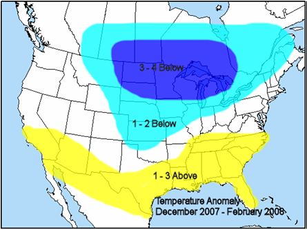
2008 Temperature Anomaly Dec 2007 to Feb 2008
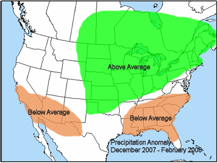
Precipitation Anomaly Dec 2007 to Feb 2008
Winter 2007 / 08 Mean Temperature and Precipitation Verification
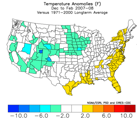

At the end of winter of 2007/08 the largely unexpected low natural gas storage condition made the upcoming summer forecast all the more critical. The fundamental basis of Dave’s forecast issued May 2008 was that summer 2008 would average much more moderate than the excessive heat of the preceding summer 2007 in the major energy consuming areas of the Midwest and East.
Summer 2008 Temperature and Precipitation Forecasts Issued May 2008
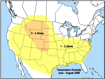
Temperature Anomaly June to August 2008
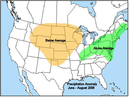
Precipitation Anomaly June to August 2008
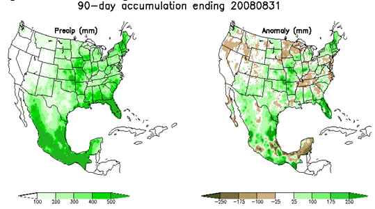
Summer 2008 Mean Temperature and Precipitation Verification

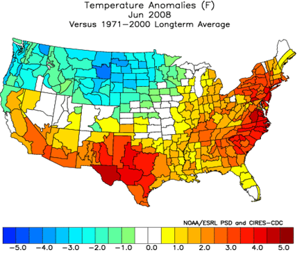
Among the listed primary forecast components issued in May was the following: “June is forecast to represent the greatest positive departures from average temperatures in the northern mid Atlantic and Northeast of the upcoming summer.”
Dave’s June Forecast

Observed June 2008
November 4 - Long Range Summary
Seasonably cold Canadian air focusing through the Great Lakes and Northeast this past weekend is transient and will be followed by fast and strong warming by Tuesday. Meanwhile another cold winter-like airmass settling into the West marks start of several days of double-digit below average temperature anomalies and additional mountain snow set to predominate the week. Unseasonably warm Eastern U.S. temperatures peaking during the 1st half of this week are forecast to exceed 10° above average across the Great Lakes, Ohio Valley, mid Atlantic region, and Northeast. Wetter conditions (and severe weather) already underway across the central U.S. after the near record dry October observed east of the Rockies represent limitation to above average daytime high temperatures (mainly 60s), but mid 70s forecast across the drier Northeast may again approach record levels. NHC is monitoring tropical development in the western Caribbean which recent modeling is intensifying to the next hurricane in the eastern Gulf of Mexico by midweek which appears headed for landfall along the central Gulf Coast Friday or Saturday (Nov 8-9). Uncertain interaction between the potential landfalling tropical cyclone and the cold Western system forecast to eject east of the Rockies about the same time has recent models struggling with details of the next noticeable cold air outbreak set to focus through the northeastern quadrant of the U.S. during the latter half of this week. Operational model forecasts valid late this week (Nov 8-9) are several degrees colder than ensemble means across the majority of the Midwest and East but all forecasts agree noticeably cooler (and wetter) conditions will persist into the start of the following week (Nov 11-12) before the next Eastern warm-up can begin. However, at the same time all extended range models establish lower amplitude flow in mid November ending frequent winter-like cold air outbreaks into the West. This is a more persistent and expansive seasonably mild signal nearly from coast to coast into the start of December, during which longer range models continue to focus greatest magnitude above average temperatures into the north central U.S.
If your business or career depends on correctly predicting the weather, you can follow the pack or you can get ahead with MWA’s proprietary models and expert forecasts.
